Vector Data Maps
Our world constantly speeds up. But speed without direction is wasteful, if not even dangerous. Speed needs to be controlled to become useful. To achieve this we transform speed to velocity by adding direction giving us control over movement. Something very alike is currently happening with the geospatial web: Fast and beautiful map images (think: aerial photography and topographic maps) are increasingly complemented by vector data (think: road network, surface topology). Vector map technology can be used to create much more intelligent applications based on fast, beautiful and lightweight map data - instead of just images. This opens the door to a wealth of new use cases. Find examples on the AdV SmartMapping Project Website which explores the potential of public survey data with VectorTiles.
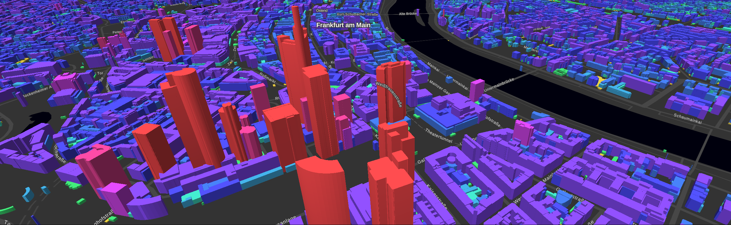
The new technology comes at a cost: Teams have to acquire a lot of new skills. Development becomes more complex and hardware requirements shift from the server to the client. Metaspatial supports the SmartMapping project in these tasks with a distributed development environment, communication framework and agile project management. If you want to learn more about how Metaspatial can help you to move forward with agile development please feel free to contact us.
Consulting and Services
Metaspatial offers consulting and agile services in for IT projects. We are specialized on geospatial and Open Source technologies and are internationally active. Our consultation and services inlcude:
- Agile project management (Scrum, Kanban, XP)
- Software development (environment, technology, architecture)
- Open Source (community, licenses, support)
- Geospatial data, software and processing
Background
Arnulf Christl works as an IT contractor. He started off as system administrator of a Sun Sparc Station 10 running the Statistic Analysis System (SAS) at the Geography Department of the University of Marburg, Germany in 1992. The first GIS explorations were based on CATLAS and later TerraFirma at the University of Alberta, Canada. Back in Germany Arnulf founded his first business "Consulting Center for GIS" which he later merged into the WhereGroup.
In 2008 Arnulf started to work under the brand Metaspatial with a focus on geospatial consulting and digital change. Through his many contacts he can help to integrate expert know-how from individual Open Source developers with large scale projects. Arnulf has an agile background, geospatial expertise and is at home on Open Source based infrastructures. Metaspatial develops, maintains and hosts web based management applications for seminar centers.
Clients
Metaspatial clients include a colorful mix of multinationals, government agencies, universities, SMEs and associations. Some of the more recent clients include:
- Arbeitsgemeinschaft der Vermessungsverwaltungen der Bundesrepublik Deutschland
- BKG- Bundesamt für Kartographie und Geodäsie
- Deutsche Telekom AG
- Ordnance Survey Great Britain
- SplashMaps Fabric Map producer
- SIEMENS AG
- Computing Center Minden Ravensberg Lippe
- Worldbank
- R3 GIS
- United Nations Habitat Office project STDN
- FIFA
- Kitzbüheler Alpen Tourist Information
- Ngakde e.V.
- European Commission
Memberships
Metaspatial actively contributes to the Open Source Geospatial Foundation (OSGeo), is a member of the FOSSGIS e.V., the EFF, associate of the 4arge GmbH and signatory of the Agile Manifesto. He served on the architecture board of the OGC (Open Geospatial Consortium) for many years.
We help to compute your IT needs since two decades.